|
Erosão pelo vento
com a retirada superficial de fragmentos mais finos. A deflação ocorre freqüentemente em
regiões de campos de dunas com a retirada preferencial de material
superficial mais fino (areia, silte), permanecendo, muitas vezes, uma
camada de pedregulhos e seixos atapetando a superfície erodida.
Pode ocorrer forte corrasão associada à deflação, esculpindo nas rochas
formas ruiniformes e outras feições típicas de regiões desérticas e outras
assoladas por fortes ventos.
Em locais de forte e constante deflação podem se formar zonas rebaixadas,
em meio a regiões desérticas, e que com as escassas chuvas formam lagos
rasos (playa), secos na maior parte do tempo; lama endurecida ou camadas
de sal atapetam, muitas vezes essas playas.
Corrasão
Processo de desbaste físico das rochas através, principalmente, do
impacto e/ou atrito de partículas transportadas pelo vento (eólica) pela
água (fluvial, de marés, correntes) ou pelo gelo (de geleira).
Abrasão
Processo erosivo ou de desgaste de rochas
pelo impacto e/ou atrito/fricção de partículas ou fragmentos carregados
por correntes eólicas, glaciais, fluviais, marinhas, de turbidez, pelo vai
e vem de ondas.
eólico
Processo, depósito sedimentar ou feição/estrutura que tem o vento como
agente geológico.
Exemplos: dunas em desertos ou praias são depósitos eólicos; corrasão
é o processo de desbaste e deflação é o de erosão eólicas.
deflação
Erosão pelo vento com a retirada
superficial de fragmentos mais finos.
A deflação ocorre freqüentemente em
regiões de campos de dunas com a retirada preferencial de material
superficial mais fino (areia, silte), permanecendo, muitas vezes, uma
camada de pedregulhos e seixos atapetando a superfície erodida.
Pode ocorrer forte corrasão associada à deflação, esculpindo nas rochas
formas ruiniformes e outras feições típicas de regiões desérticas e outras
assoladas por fortes ventos.
Em locais de forte e constante deflação podem se formar zonas rebaixadas,
em meio a regiões desérticas, e que com as escassas chuvas formam lagos
rasos (playa), secos na maior parte do tempo; lama endurecida ou camadas
de sal atapetam, muitas vezes essas playas.
|
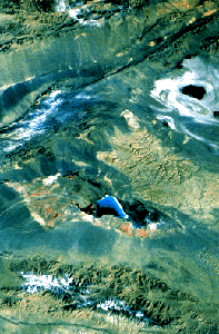
The Qaidam Depression in China is the highest
desert in the world. This Landsat image illustrates a salt lake and
evaporite basins in the depression. |
Eolian processes pertain to the activity of the winds. Winds may erode,
transport, and deposit materials, and are effective agents in regions with
sparse vegetation and a large supply of unconsolidated sediments. Although
water is much more powerful than wind, eolian processes are important in
arid environments.
Eolian Erosion
Wind erodes the Earth's surface by deflation, the removal of loose,
fine-grained particles by the turbulent eddy action of the wind, and by
abrasion, the wearing down of surfaces by the grinding action and sand
blasting of windborne particles.
The sand and rock of China's Turpan Depression
resemble closely those in the view of the Martian surface shown in "Types
of Deserts." |
Veja Superficie de Marte
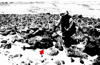
The arrow points to shiny black desert varnish
on these rocks of Egypt's southwest desert (photograph by Carol Breed).
|
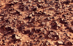
Most eolian deflation zones are composed of desert pavement, a
sheetlike surface of rock fragments that remains after wind and water have
removed the fine particles. Almost half of the Earth's desert surfaces are
stony deflation zones. The rock mantle in desert pavements protects the
underlying material from deflation.
A dark, shiny stain, called desert varnish or rock varnish, is often
found on surfaces of some desert rocks that have been exposed at the
surface for a long period of time. Manganese, iron oxides, hydroxides, and
clay minerals form most varnishes and provide the shine.
Deflation basins, called blowouts, are hollows formed by the removal of
particles by wind. Blowouts are generally small, but may be up to several
kilometers in diameter.
Wind-driven grains abrade landforms. Grinding by particles carried in
the wind creates grooves or small depressions. Ventifacts are rocks which
have been cut, and sometimes polished, by the abrasive action of wind.
Sculpted landforms, called yardangs, are up to tens of meters high and
kilometers long and are forms that have been streamlined by desert winds.
The famous sphinx at Giza in Egypt may be a modified yardang.
|
|
| A |
B |
|
| C |
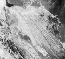
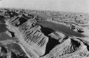
| Yardangs of the
Lut desert of Iran. View from Landsat (A), from high-altitude
photograph (B), and from low-altitude photograph (C). These yardangs
are among the largest on Earth, with almost 100 meters of relief (low-altitude
photograph by J.T. Daniels, aerial photograph by U.S. Air Force).
|
Eolian transportation
Particles are transported by winds through suspension, saltation, and
creep.
Small particles may be held in the atmosphere in suspension.
Upward currents of air support the weight of suspended particles and hold
them indefinitely in the surrounding air. Typical winds near the Earth's
surface suspend particles less than 0.2 millimeters in diameter and
scatter them aloft as dust or haze.
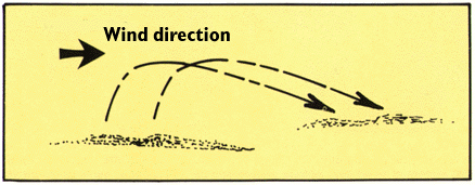
Saltation moves small particles in the direction
of the wind in a series of short hops or skips.
|
Saltation is downwind movement of particles in a series of jumps
or skips. Saltation normally lifts sand-size particles no more than one
centimeter above the ground, and proceeds at one-half to one-third the
speed of the wind. A saltating grain may hit other grains that jump up to
continue the saltation. The grain may also hit larger grains that are too
heavy to hop, but that slowly creep forward as they are pushed by
saltating grains. Surface creep accounts for as much as 25 percent of
grain movement in a desert.
Eolian turbidity currents are better known as dust storms. Air
over deserts is cooled significantly when rain passes through it. This
cooler and denser air sinks toward the desert surface. When it reaches the
ground, the air is deflected forward and sweeps up surface debris in its
turbulence as a dust storm.
Crops, people, villages, and possibly even climates are affected by
dust storms. Some dust storms are intercontinental, a few may circle the
globe, and occasionally they may engulf entire planets. When the Mariner 9
spacecraft arrived at Mars in 1971, the entire planet was enshrouded in
global dust.
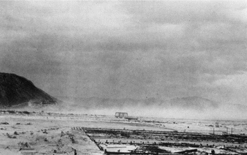
Dust storm along the Mohave River near Daggett,
California, October 24, 1919 (photograph by D. G. Thompson).
|
Most of the dust carried by dust storms is in the form of silt-size
particles. Deposits of this windblown silt are known as loess. The
thickest known deposit of loess, 335 meters, is on the Loess Plateau in
China. In Europe and in the Americas, accumulations of loess are generally
from 20 to 30 meters thick.
Small whirlwinds, called dust devils, are common in arid lands
and are thought to be related to very intense local heating of the air
that results in instabilities of the air mass. Dust devils may be as much
as one kilometer high.
Eolian deposition
Wind-deposited materials hold clues to past as well as to present wind
directions and intensities. These features help us understand the present
climate and the forces that molded it. Wind-deposited sand bodies occur as
sand sheets, ripples, and dunes.
Sand sheets are flat, gently undulating sandy plots of sand
surfaced by grains that may be too large for saltation. They form
approximately 40 percent of eolian depositional surfaces. The Selima Sand
Sheet, which occupies 60,000 square kilometers in southern Egypt and
northern Sudan, is one of the Earth's largest sand sheets. The Selima is
absolutely flat in some places; in others, active dunes move over its
surface.
Wind blowing on a sand surface ripples the surface into crests
and troughs whose long axes are perpendicular to the wind direction. The
average length of jumps during saltation corresponds to the wavelength, or
distance between adjacent crests, of the ripples. In ripples, the coarsest
materials collect at the crests. This distinguishes small ripples from
dunes, where the coarsest materials are generally in the troughs.
|
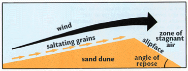
| Wind-blown sand
moves up the gentle upwind side of the dune by saltation or creep.
Sand accumulates at the brink, the top of the slipface. When the
buildup of sand at the brink exceeds the angle of repose, a small
avalanche of grains slides down the slipface. Grain by grain, the dune
moves downwind. |
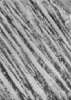
Accumulations of sediment blown by the wind into a mound or ridge,
dunes have gentle upwind slopes on the wind-facing side. The downwind
portion of the dune, the lee slope, is commonly a steep avalanche slope
referred to as a slipface. Dunes may have more than one slipface.
The minimum height of a slipface is about 30 centimeters.
Sand grains move up the dune's gentle upwind slope by saltation and
creep. When particles at the brink of the dune exceed the angle of repose,
they spill over in a tiny landslide or avalanche that reforms the slipface.
As the avalanching continues, the dune moves in the direction of the wind.
Some of the most significant experimental measurements on eolian sand
movement were performed by Ralph Bagnold, a British engineer who worked in
Egypt prior to World War II. Bagnold investigated the physics of particles
moving through the atmosphere and deposited by wind. He recognized two
basic dune types, the crescentic dune, which he called "barchan," and the
linear dune, which he called longitudinal or "sief" (Arabic for "sword").
|
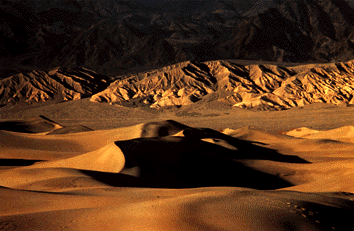
| Sand dunes in Death Valley,
California (photograph by Richard Frear). |
|