|
-
|
Rio Colorado é um rio dos Estados Unidos da
América e do México. É o rio que atravessa o Grand Canyon.
O rio Colorado corta a região mais árida da América do
Norte. A sua bacia hidrográfica tem 632.000 km², e vai desde
as Montanhas Rochosas do Colorado até o Golfo da Califórnia,
no México, passando por cinco estados americanos. Ao todo,
tem 2320 km de extensão e é um dos rios mais longos da
América do Norte.
Cerca de 80 km antes da foz, forma um pequeno trecho da
fronteira Estados Unidos da América-México. Em seu curso
alto e médio, o rio segue por um terreno acidentado,
atravessando vários cânions, como o Grand Canyon.
|

Bacia hidrográfica do Rio
Colorado |
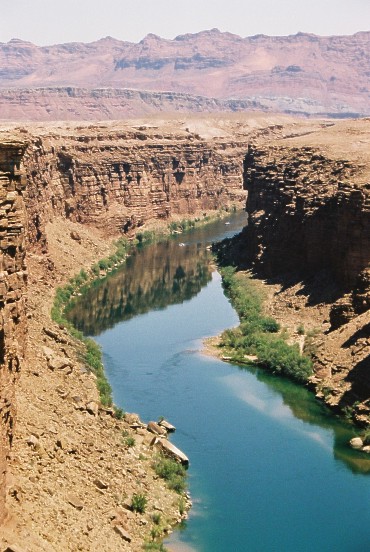
Rio Colorado na altura do Grand
Canyon
Comprimento 2 320 km
Nascente Montanhas Rochosas
Foz Golfo da Califórnia
Área da bacia 632.000 km2
País(es) Estados Unidos
México |
Recebe as águas do rio Kanab,
rio Paria, rio Escalante, rio San Rafael, rio Pequeno
Colorado, rio San Juan e rio Dolores, que cortam
transversalmente os cânions. No curso inferior, no Arizona
e na Califórnia, percorre a depressão de Salton, região
desértica que se prolonga por 275 km até a foz.
Aproveitamento do rio
Bacia
hidrográfica do Rio Colorado.A bacia hidrográfica do
Colorado é uma das mais aproveitadas do mundo. A Barragem
de Hoover, perto de Las Vegas, controla o regime do rio,
que conta com numerosos canais de irrigação e diques e é
usada para navegação e lazer. Em 1922 criou- se um órgão,
no qual o México se uniu em 1944, encarregado de
distribuir suas águas pelo território por ele banhado.
Em 1945 concluíram-se as obras que permitiram o
deslocamento das águas do rio para verte- las no norte do
Colorado, onde as terras irrigadas se ampliaram, abrindo
284 mil hectares.
O rio Colorado ( "Aha Kwahwat em
Mojave) é um rio no sudoeste Estados Unidos e do noroeste
do México, cerca de 1450 milhas (2330 km) de comprimento,
drenando uma parte das regiões áridas na encosta ocidental
da Montanhas Rochosas. O curso natural do rio desagua no
Golfo da Califórnia, mas o uso do rio como uma fonte de
irrigação para a Imperial Valley desidratado tem o curso
inferior do rio, no México tal que já não consistentemente
atinge o mar.
O rio Colorado drena 242.900 sq mi
(629,100 km ²). Fluxos totais do rio variam de 4.000
metros cúbicos por segundo (113 m³ / s) no secas para
1000000 pés ³ / s (28.000 m³ / s) em graves inundações.
Com a construção de barragens no maciço poder curso
inferior do rio, os fluxos de mais de 70.000 ft ³ / s
(2000 m³ / s) são incomuns. A média de fluxo do rio era
22.000 ft ³ / s (620 m³ / s), durante o período entre
1903-34. A partir de 1951-80, a vazão média foi inferior a
4000 ft3 / s. Historicamente, o fluxo era muito maior
antes da utilização da água começou na bacia.
Mais
informação a tradução não esta legivel
Historia
Precoce registros
A existência do rio Colorado
foi referido pela primeira vez nos registros da história
escrita em setembro de 1539, quando Francisco de Ulloa
rumou para a cabeça do Golfo da Califórnia e rowed uma
curta distância a montante. Foi visto pela próxima
Hernando de Alarcon, que em 1540 levou o contingente de
Coronado marítima da expedição. O plano tinha como
objectivo satisfazer as terras baseada vigor e
reabastecer-los. Alarcon o rio subiu cerca de 85 milhas
para espanhol do limite de navegação de hoje perto de
Yuma, Arizona. Ele esperou por Coronado, mas acabou se
desesperavam, cached alguns suprimentos e correspondência,
deixou uma nota sobre uma árvore, e partiu. Coronado's
forças terrestres nunca chegou a esse local, mas Melchior
Diaz, em sua terceira expedição, correu para ver se ele
pode estabelecer contato com Alarcon. Por o tempo que ele
atingiu o Colorado, no entanto, já tinha deixado Alarcon.
Os americanos nativos lhe disse o que sabia da
presença de Alarcon e que ele havia deixado um cache de
fornecimentos. Diaz encontrada a nota e as entregas. Diaz
chamado o rio Tizon del Rio ( "Rio de brasas" ou
"Firebrand River"), baseado em uma prática usada pelos
nativos para aquecimento si. Entretanto, Coronado (que na
altura estava perto Zuni, Novo México) tinha aprendido a
partir de uma aferição dos seus partidos que os nativos
falaram de um grande rio para o oeste. Ele enviou Garcia
Lopez de Cardenas para liderar um contingente de homens
para encontrar este rio. Eles não encontrá-lo no que é
hoje conhecido como o Grand Canyon, tornando-se o primeiro
povo do fundo europeu para vê-la. As suas tentativas
falhadas de chegar ao rio os levou a concluir que não
seria possível de ser fornecido através do Golfo da
Califórnia e do rio.
Rio Colorado no Grand
Canyon do Deserto ViewThe ano seguinte, Francisco de
Bolanos navegou até à foz do rio sobre o Golfo da
Califórnia. Um de seus pilotos, Domingo del Castillo,
preparou um mapa da costa mexicana. Ele cartografado três
rios na cabeça do golfo e nomeou-os Brazo de Laguna p.,
Rio de buena p. da Guia, e Brazo de Mira Flores p.. A
última delas é a mais longa. Posteriormente referências
sugerem que Brazo de Mira Flores refere ao que é agora
chamado de Gila River, e que Rio de buena Guia era o nome
dele para o Colorado. (Apesar destes registos, o erro que
a Califórnia era uma ilha persistiu por mais de um século,
especialmente entre os europeus cartógrafos.)
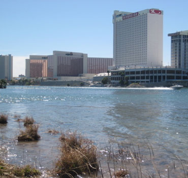
O rio Colorado LaughlinComparisons partir do 17o, 18o, e
no início do século 19. Mapas revelam um desfile de nomes
a ser aplicada ao Colorado, e seus afluentes, bem como uma
variedade de cursos, como cartógrafos aprendeu ou inventou
a geografia da região. Em um mapa por Nicholas Sanson
(1650), a R. del TECON e da R. de Coral compartilham uma
boca sobre o golfo. Uma série de mapas mostram a Gila
River (por vezes apenas o menor, por vezes, a totalidade),
como o Rio Grande do Apóstoles las. Um mapa 1763 por
Emanuel Bowen equipara os Apóstolos com o Coral del. Um
mapa de 1720 Fer Nicholas rótulos o corpo principal do
Colorado como Tison del Rio, e um afluente do Apóstolos /
Gila como Rio Colorade. Em 1703 Guillaume de L'Isle
mostrou um Rio de buena esperanza como um importante
afluente do Tison, mas não está claro se este afluente
corresponde melhor com os Little Colorado ou de San Juan.
Um mapa de Herman Moll (1720) e os gráficos do Tison Gila
com distintos boca. Rio acima a partir de um afluente do
Tison, que parecem corresponder com a de hoje Virgin
River, o nome para o canal principal, é dado a R. da Boa
Esperança.
Em outros mapas Boa Esperança / Buena
Esperanza são transferidos para um afluente do Gila. Um
mapa de 1757 dá o nome do curso principal do Rio Colorado
de los Martyres. Um mapa de 1781 por Jonathan Carver
gráficos uma grande divisão do rio e os rótulos Oriental
ramo "Colorado" e o ramo ocidental Martyres. Um mapa de
1758 por Didier Robert de Vaugondy se aplica o nome de um
rio Colorado, que atinge norte até as cabeceiras do
Missouri, correspondentes ao melhor hoje Green River.
Quando chegou o primeiro Jedediah Smith inferior Colorado
em 1826, ele chamou-lhe a primeira Seedskeedee, como nas
cabeceiras do Rio Verde foram conhecidos da caçadores, mas
também observou que os nativos chamam-lhe o Colorado.
Não está claro quando ou porque o nome de "Colorado"
primeiro substituiu "Tizon" (TECON / Tison), que tinha
sido o nome mais comum em mapas desde 1540. Entre os mapas
na Biblioteca do Congresso, a cada uso do "Colorado" (ou
Colorade) de 1720 e antes de ser aplicada a um afluente do
que é hoje a Gila River que parece melhor para
corresponder com o Rio Verde de hoje. O primeiro mapa em
que a recolha, que substitui "Tizon" com o "Colorado" é um
mapa a partir de 1743.
O mapa que resultaram
Escalante da expedição em 1776 rótulos o canal principal
como o Colorado até a confluência dos rios Nabajoo e
Zaguananas. A informação associada leva um a concluir que
a Nabajoo corresponde à San Juan e as Zaguananas para o
Colorado a partir daí para o rio Dolores. Neste mapa do
Colorado acima da Dolores é chamado de Rafael, e do Rio
Verde (chamado Buenaventura Rio) é erroneamente desviados
para o sudoeste, e em que agora é chamado Lago Sevier.
Quando Escalante da revista registros sua travessia do San
Rafael, ele observa que os americanos nativos conhecia
este rio como o Colorado. Ele também observa que os
indígenas disseram que este rio tinha origem em um lago
distante, mas o lago não é traçado sobre o mapa
resultante. É evidente a partir de uma série de mapas do
período em que as pessoas não estavam conscientes da
distância entre o Colorado da confluência com o Dolores e
as encostas ocidentais da Frente Gama. Em um mapa a partir
de 1847 por John Disturnell, o Rafael é substituído com o
Green River, enquanto a parte superior do Colorado (ou,
mais correctamente, o que seria chamado o Grande Rio) não
é mostrada em todos.
Grande Rio
"Grande
Rio" é o nome, uma vez aplicado ao rio Colorado a partir
de suas nascentes no Parque Nacional das Montanhas
Rochosas à sua confluência com o Rio Verde, em Utah. Isto
deu origem a vários nomes, incluindo agora órfãs Grande
Lago, Grand Valley, Grand Junction, Grand County,
Colorado, e Grand County, Utah. A primeira aparição de um
mapa sobre esse nome poderia ser no mapa por Henry Schenck
Tanner (1836). O nome lá substitui o nome de Rio Rafael,
que aparece em muitos mapas anteriores. O chefe deste ramo
do Colorado é apresentado como mais ou menos na mesma
latitude que longos Peak, no Colorado. Não há nada que
corresponde ao traçado Green River, que não corresponde
com o curso da Dolores (apesar de alguns mapas que mostram
o anterior Dolores com razoável precisão), e nas
cabeceiras, tanto do Rio Grande ( "Rio del Norte") e,
sobretudo, o rio Arkansas são indicados para chegar a uma
maior latitude.
Um mapa de David H. Burr (1839)
mostra a "rio Colorado do Oeste" decorrentes das
cabeceiras do Rio Verde para o Golfo da Califórnia, com o
"Grande Rio", como um afluente ramificação para o leste, o
terceiro afluente rio acima a partir do Nabajoo (San
Juan). O Green River é chamado não separadamente. As
cabeceiras do Grande são representadas como estando muito
perto da nascente do Rio Grande (que é identificado como
"Rio Bravo del Norte"), bem como as do rio Arkansas. Uma
nota textuais no mapa indica que pouco se sabe desta área.
Em 1921, Edward T. Taylor E.U. Representante
manifestaram o Congresso Comité Interestatal sobre
Comércio Exterior e para mudar o nome do Rio Grande como o
Colorado River. Em 25 de julho de 1921 foi feita a
alteração do nome oficial na Assembleia Comum Resolução
460 do 66o Congresso, sobre as acusações de representantes
de Wyoming e Utah e do United States Geological Survey,
que notar que a bacia de drenagem do Rio Verde foi mais de
70 % a mais extensa do que a do Rio Grande, embora a um
nível ligeiramente superior transportadas Grande volume de
água na sua confluência com o verde.
Horseshoe
Bend é uma forma de ferradura meandro do rio Colorado
localizada perto da cidade de Page, Arizona
Curso
Pré-História
É a opinião de alguns geólogos
que, antes do Golfo da Califórnia entrou em vigor em cerca
de 7-8 milhões de anos atrás, o rio Colorado inicialmente
tinha a sua saída em algum lugar ao longo que é agora a
Califórnia costa. Eles acreditam que o massivo Monterey
Canyon submarino sob Monterey Bay juntamente com os
associados sedimentares submarinos ventilador pode ser
remanescentes de Colorado do antigo ponto de venda. A
norte canyon se mudou para a sua localização actual por
acção da Falha de San Andreas e teria Santa Barbara sido
de aproximadamente onde está localizado, quando ambos
Falha de San Andreas e do Golfo da Califórnia entrou em
estar.
Hoje
A fonte do rio Colorado é La
poudre Pass Lago, situado no alto do Parque Nacional das
Montanhas Rochosas, apenas a oeste do Continental Divide.
Abaixo Rocky Mountain National Park, o rio que flui
através do Kawuneeche Vale e, em seguida, através de
fluxos Grande Lago, a maior massa de água natural no
Colorado, antes de ser represado para criar Shadow
Mountain Reservatório. O rio desemboca no lago Granby
então, um outro reservatório, e, finalmente, começa a sua
viagem para o Golfo da Califórnia onde E.U. Highway 40
aproximadamente paralelos ao rio para a cidade de
Kremmling, onde ela entra Gore Canyon. A maior parte dos
afluentes do rio Colorado dentro são pequenas.
No entanto, há excepções, como a Gunnison e Loucos Fork
Rivers, em que enormes quantidades de água corrente. Cerca
de uma centena de milhas mais tarde se reúne a Eagle
River, na cidade de Dotsero, Colorado, onde I-70 e
paralelos ao rio através Glenwood Canyon. O rio, em
seguida, atravessa a cidade de Glenwood Springs onde se
juntou pela rapidez fluindo Roaring Fork River. Oeste de
Glenwood Springs, Colorado atravessa o Vale do Grande e
juntou-se a Gunnison River em Grand Junction. De lá, ela
flui para o oeste Utah fronteira e Westwater Canyon. O
Colorado aqui varia de 200 a 1200 pés de largura (60 a 370
m) e de 6 a 30 pés de profundidade (2 a 9 m), com
eventuais áreas mais profundas.
Um remoto
trecho do rio Colorado do Escalante na Grande Rota
CanyonThe rio vira sudoeste perto Fruita, Colorado, e se
uniram pelo Dolores rio logo após entrar Utah. Ela faz
parte da fronteira sul do Parque Nacional Arches perto de
Moab, Utah, e depois passa por Dead Horse Point State Park
e através Canyonlands Parque Nacional onde se reuniu por
um dos seus principais afluentes, o Rio Verde. O Colorado,
então flui em Lake Powell, formado pela Barragem Glen
Canyon. Abaixo da barragem, a água liberada a partir do
fundo do lago Powell faz com que o rio claro, limpo e
frio. Arizona, o rio faz a dramática Horseshoe Bend, em
seguida, em Lees Ferry se juntou a outro afluente, a
quente, raso, enlameada Paria River, e inicia o seu curso
através Marble Canyon. Aqui, o Colorado vai de 175 a 700
pés de largura (53 a 213 m) e de 9 a 130 pés de
profundidade (3 a 40 m).
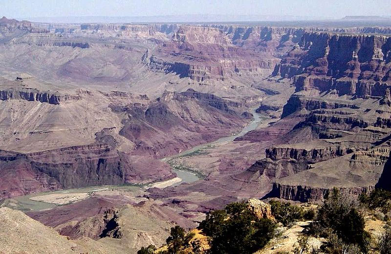
No extremo sul de Marble
Canyon, o rio se une por outro afluente, o Little
Colorado, e em seguida o rio vira abruptamente oeste
diretamente em toda a linha de falhas e dobras do
planalto, através do Grand Canyon, que é 217 milhas de
comprimento (349 km) e de 4 a 20 milhas de largura (de 6 a
30 km) entre a parte superior do penhasco. As paredes,
4000 a 6000 metros de altitude (1200 a 1800 m), cair em
sucessivas escarpas de 500 a 1600 pés (150 a 490 m), em
faixas de cores para o esplêndido estreito desfiladeiro do
presente rio.
Abaixo da confluência do rio Virgem
de Nevada, o Colorado abruptamente gira sul. Hoover Dam,
construída durante a Grande Depressão, formas lago Mead,
um popular site recreação, bem como o fornecedor da maior
parte da água para a cidade de Las Vegas. De Hoover Dam, o
rio que flui sul e faz parte da fronteira entre o Arizona
e Nevada e entre Arizona e Califórnia. Ao longo da
Califórnia, Arizona alcance do rio, mais quatro barragens
são operados para desviar água para irrigação agrícola e
para a recreação. Lago Mohave, formado por Davis Dam,
encontra-se na porção sul do lago Mead National Recreation
Area. Lake Havasu, formada por Parker Dam, proporciona
lazer, bem como a casa do aposentado New London Bridge. As
restantes duas barragens abastecimento da água: Palo Verde
Diversion Dam Dam e Imperial. Aqui, o rio Colorado em
largura varia de 700 a 2500 pés (210 a 760 m) e 8-100 pés
de profundidade (2 a 30 m).
Abaixo o Black Canyon
do rio diminui em declive e em seu curso inferior fluxos
sedimentares em um amplo vale do rio acima da planície
estuarina distintos Yuma, onde se juntou pela Gila River.
O canal através de uma grande parte desta região é rodadas
em um dique-como aterro situada acima da planície ao longo
do qual a água derrames escapar em tempo de cheias. Este
dique corta o fluxo do rio para a zona baixa notável no
sul da Califórnia conhecida como a Salton Sink, Coachella
Valley, ou Imperial Valley. A Salton Sumidouro está
localizado abaixo do nível do mar e, portanto, a descida
do rio perto de Yuma é muito maior do que a descida da
Yuma para o abismo.
O curso inferior do rio, que
forma a fronteira entre a Baixa Califórnia e de Sonora, é
essencialmente uma gota ou um riacho seco hoje devido ao
uso do rio como fonte de irrigação do Vale Imperial. Antes
de meados do século 20, o Delta do Rio Colorado
proporcionou um rico estuário pantanosas que agora é
essencialmente desidratado, mas ainda assim é um
importante recurso ecológico.
Alterações
climáticas
Segundo a Defesa dos Recursos Naturais do
Conselho da Bacia do Rio Colorado, que se estende de
Wyoming para o México, está no centro das mudanças
climáticas mais quentes no oeste dos Estados Unidos. Desde
a década de 1970, contribuíram para aumento das
temperaturas anteriores snowmelts, ea bacia tem aquecido
mais do que qualquer outro na área contígua Estados
Unidos.
Como resultado, o volume de água na bacia
está a diminuir. Os anos de 2000 a 2004 foram os únicos
cinco anos consecutivos na história gravada com água
abaixo da média. Lake Powell, um dos principais
reservatórios da bacia, é de apenas 45 por cento cheio.
Elevação resumo
Aproximado altura acima do
nível do mar em diversos locais chave:
Pés Metros
Localização
9000 2750 Colorado cabeceiras (Rocky
Mountains)
6100 1850 ao meio-Colorado Utah fronteira
4300 1300 Colorado, Utah fronteira
3850 1170 ao
meio-Utah Arizona fronteira
3700 1130 Utah, Arizona
fronteira (Wahweap Bay)
3000 900 meio de Grand Canyon
(Rider Point)
2800 850 Grand Canyon North Rim
2500
760 Grand Canyon South Rim
1200 365 Lake Mead (acima
Hoover Dam)
600 183 abaixo Hoover Dam
485 150
Califórnia-Nevada-Arizona border
100 30
Califórnia-Arizona-México fronteira
Note que a
diferença significativa entre a altura de apresentar o aro
do Grand Canyon (cerca de 8.000 pés; 2440 m) e os níveis
em que o rio entrada / saída que dá origem à teoria de que
a sua geológicas turbulência deve ter começado em torno do
mesmo tempo, o rio começou a fluir através dele e erodindo
ele (desde rios não correm para cima, caso contrário teria
seguido um outro caminho em torno da agitação).
Estimativas para o início desta erosão / turbulência
processo variam de 5 a 70 milhões de anos atrás.
Engenharia
Glen Canyon Dam e Lake PowellIn o
Outono de 1904, as águas do rio fugiu em um desvio do
canal a alguns quilômetros abaixo Yuma, Arizona, a criação
do Novo Rio e Rio Alamo. Os rios re-criada na Califórnia
um grande mar interior, em uma área que tinha
frequentemente inundadas antes, por exemplo, em 1884 e
1891, quando ele tinha um tempo para praticamente
abandonado seu antigo território mexicano através de curso
para o Mar de Cortez. Contudo, foi efetivamente represado
na primeira parte de 1907 e voltou ao seu curso normal, a
partir da qual, no entanto, havia ainda muita fuga ao Mar
Salton. Em Julho de 1907, a barragem foi concluída
permanente. Do Black Canyon do Colorado para o mar
normalmente flui através de um deserto-como bacia.
Do Hoover DamThe Colorado River é uma grande e em
alguns casos vida-sustentação fonte de água para
irrigação, beber, e de outras aplicações por pessoas que
vivem em zonas áridas do sudoeste americano. Alocação de
água do rio é regido pelo rio Colorado Compact. Várias
barragens foram construídas ao longo do rio Colorado, que
começa com Glen Canyon Dam Utah-Arizona perto da
fronteira. Outras barragens incluem Hoover Dam, Parker
Dam, Davis Dam, Palo Verde Diversion Dam, e Imperial
Barragem. Desde a conclusão das barragens, a maioria do
rio, em anos normais hidrológicas são desviados para fins
agrícolas e municipais de abastecimento de água.
As últimas gotas do Colorado evaporar no Deserto Sonoran,
milhas até o rio atinja o Golfo da Califórnia. Quase 90%
do total de água do rio é desviada para fins de irrigação.
The All-American Canal é o maior canal de irrigação do
mundo, e comporta um volume de água de 15.000-30.000 ft ³
/ s (420 a 850 m³ / s), tornando-o maior volume do que em
Nova York do rio Hudson. O canal de águas são utilizadas
para irrigar o erma mas fértil Imperial Valley, onde pode
passar vários anos entre mensuráveis das chuvas.
Hidrologia transporte modelos são utilizados para avaliar
a gestão do fluxo do rio e da qualidade da água.
Hoover Dam (originalmente Boulder Dam, ea primeira
barragem do seu tipo) foi concluída em 1936. Seu
represamento do rio no Deserto Mojave cria lago Mead, que
fornece água para a irrigação ea geração de energia
hidroelétrica.
Várias cidades como Los Angeles,
Las Vegas, San Bernardino, San Diego, Phoenix e Tucson têm
aqueducts levando todo o caminho de volta ao rio Colorado.
Um destes é o aqueduto Central Arizona Project ( "PAC") do
canal, que foi iniciado na década de 1970 e terminaram na
década de 1990. O canal começa a Parker Dam e executa todo
o caminho até Phoenix e Tucson, em seguida, para
complementar essas cidades "água necessidades.
O
menor é navegável por Colorado moderados a grandes e
médias embarcações. O menor rio de Davis Dam até Yuma
grande roda de pás é navegável por barcos e batelões rio,
mas navegação comercial no rio não é importante, porque o
rio é cortado a partir do mar, tornando a outros meios de
transporte mais eficiente na região. Antes da ferrovia
chegou, o menor Colorado River entre o mar perto de hoje
Laughlin, Nevada foi um importante meio de transporte por
grandes vapor. A maior parte do resto do rio, excluindo as
corredeiras nos desfiladeiros, é navegável por pequenas a
moderadas e médias embarcações fluviais e poder barcos.
Colorado River
Moab urânio rejeitos
Atlas Mineral Corporation operado uma fábrica de
processamento de urânio na zona de Moab, Utah, na margem
norte do rio Colorado pouco menos de três milhas (5 km) do
centro de Moab. Como um subproduto do processamento de
urânio actividades, um número estimado de 16 milhões ton
pilha de rejeitos perigosos quimicamente e
radioactivamente existe. A pilha está localizada a cerca
de 700-800 pés a partir do rio Colorado. Embora nenhuma
contaminação foi detectada, a proximidade do material para
a bacia hidrográfica tem sido uma preocupação. O Senado
tem autorizado os E.U. Departamento de Energia do
orçamento $ 22,8 milhões em 2007 para iniciar o projeto de
passar o urânio rejeitos mais longe do rio. O plano é para
mover os materiais contaminados 30 milhas (48 km) a norte
localizado em um local de eliminação Crescente Junction,
Utah. O projeto está previsto para ser concluído até 2028
com os actuais planos de financiamento, pelo custo total
estimado de E.U. $ 720 milhões.
Vida Selvagem
A bacia do rio Colorado é o lar de quatorze espécies
nativas de peixes. Quatro são endêmicas e ameaçadas:
Colorado pikeminnow (ex-Colorado squawfish), porco
selvagem sucker, bonytail caboz, e corcunda caboz. O Upper
Colorado River Ameaçadas Peixe Recuperação Programa é um
esforço por controversos os E.U. Fish and Wildlife
Service, em conjugação com o Arizona e Game Fish
Departamento, a Divisão de Fauna Silvestre Colorado, Utah
e do Departamento de Vida Selvagem recuperar esses peixes
ameaçadas.
Inglês
The Colorado River ('Aha
Kwahwat in Mojave) is a river in the southwestern United
States and northwestern Mexico, approximately 1,450 mi
(2,330 km) long, draining a part of the arid regions on
the western slope of the Rocky Mountains. The natural
course of the river flows into the Gulf of California, but
the heavy use of the river as an irrigation source for the
Imperial Valley has desiccated the lower course of the
river in Mexico such that it no longer consistently
reaches the sea.
The Colorado River drains 242,900
sq mi (629,100 km²). Total flows of the river range from
4000 cubic feet per second (113 m³/s) in droughts to
1,000,000 ft³/s (28,000 m³/s) in severe floods. With the
construction of massive power dams on the lower course of
the river, flows of over 70,000 ft³/s (2000 m³/s) are
unusual. The mean flow of the river was 22,000 ft³/s (620
m³/s) during the period between 1903-34. From 1951-80, the
average flow was less than 4,000 ft3/s. Historically the
flow was much higher before water usage began in the
basin.
History
Early records
The
existence of the Colorado River was first noted in the
records of written history in September, 1539, when
Francisco de Ulloa sailed to the head of the Gulf of
California and rowed a short distance upstream. It was
next seen by Hernando de Alarcon who in 1540 led the
maritime contingent of Coronado's expedition. The plan was
to meet the land based force and resupply them. Alarcon
ascended the river about 85 Spanish miles to the limit of
navigation near present-day Yuma, Arizona. He waited for
Coronado, but eventually despaired, cached some supplies
and correspondence, left a note on a tree, and departed.
Coronado's land forces never reached that location, but
Melchior Diaz, on his third expedition, went to see if he
could establish contact with Alarcon. By the time he
reached the Colorado, however, Alarcon had already left.
The Native Americans told him what they knew of Alarcon's
presence and that he had left a cache of supplies. Diaz
found the note and the supplies. Diaz named the river Rio
del Tizon ("River of Embers" or "Firebrand River") based
on a practice used by the natives for warming themselves.
Meanwhile, Coronado (who at the time was near Zuni, New
Mexico) had learned from one of his scouting parties that
the natives spoke of a large river to the west. He sent
Garcia Lopez de Cardenas to lead a contingent of men to
find this river. They did find it at what is now known as
the Grand Canyon, becoming the first people of European
background to see it. Their failed attempts at reaching
the river led them to conclude that it would not be
possible to be supplied via the Gulf of California and the
river.
Colorado River in the Grand Canyon from
Desert ViewThe following year, Francisco de Bolanos sailed
to the mouth of the river on the Gulf of California. One
of his pilots, Domingo del Castillo, prepared a map of the
Mexican coast. He charted three rivers at the head of the
gulf and named them Brazo de laguna p., Rio de buena Guia
p., and Brazo de Mira flores p.. The last of these is the
longest. Later references suggest that Brazo de Mira
flores referred to what is now called the Gila River, and
that Rio de buena Guia was his name for the Colorado. (In
spite of these records, the error that California was an
island persisted for more than a century, especially among
European cartographers.)
The Colorado River
from LaughlinComparisons of 17th, 18th, and early
19th-century maps reveal a parade of names being applied
to the Colorado and its tributaries, as well as a variety
of courses, as cartographers learned or made up the
geography of the region. On a map by Nicholas Sanson
(1650) the R. del Tecon and the R. de Coral share a common
mouth on the gulf. A number of maps show the Gila River
(sometimes just the lower, sometimes the whole) as the Rio
Grande de las Apostoles. A 1763 map by Emanuel Bowen
equates the Apostles with the del Coral. A 1720 map by Fer
Nicholas labels the main body of the Colorado as Rio del
Tison, and a tributary of the Apostles/Gila as Rio
Colorade. In 1703 Guillaume de L'Isle showed a Rio de
buena esperanza as a major tributary of the Tison, but it
is not clear if this tributary corresponds better with the
Little Colorado or the San Juan.
A map by Herman Moll
(1720) charts the Tison and the Gila with separate mouths.
Upriver from a tributary of the Tison that would appear to
correspond with today's Virgin River, the name for the
main channel is given as R. of Good Hope. On other maps
Good Hope/Buena Esperanza are transferred to a tributary
of the Gila. A map of 1757 gives the name of the main
course as Rio Colorado de los Martyres. A map of 1781 by
Jonathan Carver charts a major split in the river and
labels the eastern branch "Colorado" and the western
branch Martyres. A map from 1758 by Didier Robert de
Vaugondy applies the name Colorado to a river that reaches
north to the headwaters of the Missouri, best
corresponding to today's Green River. When Jedediah Smith
first reached the lower Colorado in 1826, he first called
it the Seedskeedee, as the headwaters of the Green River
were known to the trappers, but also noted that the
natives called it the Colorado.
It is not clear
when or why the name "Colorado" first replaced "Tizon"
(Tecon/Tison), which had been the most common name on maps
since 1540. Among the maps in the Library of Congress,
every use of "Colorado" (or Colorade) from 1720 and before
is applied to a tributary of what is now the Gila River
that seems best to correspond with today's Verde River.
The earliest map in that collection that replaces "Tizon"
with "Colorado" is a map from 1743.
The map that
resulted from Escalante's expedition in 1776 labels the
main channel as the Colorado up to the confluence of the
Nabajoo and Zaguananas rivers. The associated information
leads one to conclude that the Nabajoo corresponds to the
San Juan and the Zaguananas to the Colorado from there to
the Dolores River. On this map the Colorado above the
Dolores is called the Rafael, and the Green River (named
Buenaventura River) is erroneously diverted to the
southwest and to what is now called Sevier Lake. Where
Escalante's journal records his crossing of the San
Rafael, he notes that the Native Americans knew this river
as the Colorado. He also notes that the natives said this
river had it source in a distant lake, but the lake is not
charted on the resulting map. It is evident from a number
of maps of the period that people were not aware of the
distance between the Colorado's confluence with the
Dolores and the western slopes of the Front Range. On a
map from 1847 by John Disturnell, the Rafael is replaced
with the Green River, while the upper Colorado (or more
correctly, what would be called the Grand River) is not
shown at all.
Grand River
"Grand River" is
the name once applied to the Colorado River from its
headwaters in Rocky Mountain National Park to its
confluence with the Green River in Utah. This gave rise to
several now orphaned names including Grand Lake, Grand
Valley, Grand Junction, Grand County, Colorado, and Grand
County, Utah. The earliest appearance of this name on a
map could be on the map by Henry Schenck Tanner (1836).The
name there replaces the name of Rio Rafael, which appears
on many earlier maps. The head of this branch of the
Colorado is shown as at about the same latitude as Longs
Peak in Colorado. There is nothing charted that
corresponds to the Green River, nothing that corresponds
with the course of the Dolores (even though some earlier
maps did show the Dolores with reasonable accuracy), and
the headwaters of both the Rio Grande ("Rio del Norte")
and especially the Arkansas River are shown to reach to a
higher latitude.
A map by David H. Burr (1839)
shows the "Colorado River of the West" flowing from the
headwaters of the Green River to the Gulf of California,
with the "Grand River" as a tributary branching to the
east, the third tributary upriver from the Nabajoo (San
Juan). The Green River is not separately named. The
headwaters of the Grand are depicted as being very close
to the headwaters of the Rio Grande (which is labeled "Rio
Bravo del Norte") as well as those of the Arkansas River.
A textual note on the map indicates that little is known
of this area.
In 1921, U.S. Representative Edward
T. Taylor petitioned the Congressional Committee on
Interstate and Foreign Commerce to rename the Grand River
as the Colorado River. On July 25, 1921 the name change
was made official in House Joint Resolution 460 of the
66th Congress, over the objections of representatives from
Wyoming and Utah and the United States Geological Survey
which noted that the drainage basin of the Green River was
more than 70% more extensive than that of the Grand River,
although the Grand carried a slightly higher volume of
water at its confluence with the Green.
Horseshoe Bend is a horseshoe-shaped meander of the
Colorado River located near the town of Page, Arizona
Course
Prehistory
It is the opinion of some
geologists that before the Gulf of California came into
being some 7-8 million years ago, the Colorado River
initially had its outlet somewhere along what is now the
California coast. They believe that the massive Monterey
Submarine Canyon under Monterey Bay along with the
associated undersea sedimentary fan may be remnants of the
Colorado's ancient outlet.The canyon has moved north to
its current location by the action of the San Andreas
Fault and would have been approximately where Santa
Barbara is located when both the San Andreas Fault and the
Gulf of California came into being.
Today
The Colorado River's source is La Poudre Pass Lake,
located high in Rocky Mountain National Park, just west of
the Continental Divide. Below Rocky Mountain National
Park, the river flows through the Kawuneeche Valley and
then flows through Grand Lake, the largest natural body of
water in Colorado, before being dammed to create Shadow
Mountain Reservoir. The river then flows into Lake Granby,
another reservoir, and finally begins its journey to the
Gulf of California where U.S. Highway 40 roughly parallels
the river to the town of Kremmling, where it enters Gore
Canyon. Most of the river's tributaries within Colorado
are small. However there are exceptions, such as the
Gunnison and Roaring Fork Rivers, in which massive amounts
of water flow. About a hundred miles later it meets the
Eagle River in the town of Dotsero, Colorado, and where
I-70 parallels the river through Glenwood Canyon. The
river then passes through the city of Glenwood Springs
where it is joined by the swift flowing Roaring Fork
River. West of Glenwood Springs, the Colorado runs through
the Grand Valley and is joined by the Gunnison River in
Grand Junction. From there it flows westward to the Utah
border and Westwater Canyon. The Colorado here ranges from
200 to 1200 feet wide (60 to 370 m) and from 6 to 30 feet
in depth (2 to 9 m) with occasional deeper areas.
A remote stretch of the Colorado River from the
Escalante Route in the Grand CanyonThe river turns
southwest near Fruita, Colorado, and is joined by the
Dolores River soon after entering Utah. It partially forms
the southern border of Arches National Park near Moab,
Utah, and then passes by Dead Horse Point State Park and
through Canyonlands National Park where it is met by one
of its primary tributaries, the Green River. The Colorado
then flows into Lake Powell, formed by the Glen Canyon
Dam. Below the dam, water released from the bottom of Lake
Powell makes the river clear, clean, and cold. Just south
of the town of Page, Arizona, the river forms the dramatic
Horseshoe Bend, then at Lees Ferry is joined by another
tributary, the warm, shallow, muddy Paria River, and
begins its course through Marble Canyon. Here, the
Colorado ranges from 175 to 700 feet in width (53 to 213
m) and 9 to 130 feet in depth (3 to 40 m).
At the
southern end of Marble Canyon, the river is joined by
another tributary, the Little Colorado, and the river then
turns abruptly west directly across the folds and fault
line of the plateau, through the Grand Canyon, which is
217 miles long (349 km) and from 4 to 20 miles wide (6 to
30 km) between the upper cliffs. The walls, 4000 to 6000
feet high (1200 to 1800 m), drop in successive escarpments
of 500 to 1600 feet (150 to 490 m), banded in splendid
colours toward the narrow gorge of the present river.
Below the confluence of the Virgin River of Nevada,
the Colorado abruptly turns southward. Hoover Dam, built
during the Great Depression, forms Lake Mead, a popular
recreation site as well as the supplier of most of the
water for the city of Las Vegas. From Hoover Dam, the
river flows south and forms part of the boundary between
Arizona and Nevada and between Arizona and California.
Along the California-Arizona reach of the river, four
additional dams are operated to divert water for
agricultural irrigation and for recreation. Lake Mohave,
formed by Davis Dam, lies in the southern portion of the
Lake Mead National Recreation Area. Lake Havasu, formed by
Parker Dam, provides recreation as well as the home of the
retired New London Bridge. The two remaining dams supply
irrigation water: Palo Verde Diversion Dam and Imperial
Dam. Here, the Colorado River ranges in width from 700 to
2500 feet (210 to 760 m) and from 8 to 100 feet in depth
(2 to 30 m).
Below the Black Canyon the river
lessens in gradient and in its lower course flows in a
broad sedimentary valley's distinct estuarine plain
upriver from Yuma, where it is joined by the Gila River.
The channel through much of this region is bedded in a
dike-like embankment lying above the floodplain over which
the escaping water spills in time of flood. This dike cuts
off the flow of the river to the remarkable low area in
southern California known as the Salton Sink, Coachella
Valley, or Imperial Valley. The Salton Sink is located
below sea level; therefore, the descent from the river
near Yuma is very much greater than the descent from Yuma
to the gulf.
The lower course of the river, which
forms the border between Baja California and Sonora, is
essentially a trickle or a dry stream today due to use of
the river as Imperial Valley's irrigation source. Prior to
the mid 20th century, the Colorado River Delta provided a
rich estuarine marshland that is now essentially
desiccated, but nonetheless is an important ecological
resource.
Climate change
According to the
Natural Resources Defense Council the Colorado River
Basin, which stretches from Wyoming to Mexico, is at the
center of hotter climate changes in the Western United
States. Since the 1970s, rising temperatures have
contributed to earlier snowmelts, and the basin has warmed
more than any other area in the contiguous United States.
As a result, the volume of water in the basin is
decreasing. The years 2000 to 2004 were the only five
consecutive years in recorded history with water flow
below average. Lake Powell, one of the basin's main
reservoirs, is only 45 percent full.
Elevation
summary
Approximate heights above sea level at several
key locations:
Feet Meters Location
9000 2750
Colorado headwaters (Rocky Mountains)
6100 1850 midway
to Colorado-Utah border
4300 1300 Colorado-Utah border
3850 1170 midway to Utah-Arizona border
3700 1130
Utah-Arizona border (Wahweap Bay)
3000 900 midway to
Grand Canyon (Rider Point)
2800 850 Grand Canyon North
Rim
2500 760 Grand Canyon South Rim
1200 365 Lake
Mead (above Hoover Dam)
600 183 below Hoover Dam
485 150 California-Nevada-Arizona border
100 30
California-Arizona-Mexico border
Note that the
significant difference between the present height of the
rim of the Grand Canyon (about 8000 ft; 2440 m) and the
levels at which the river enters/exits it gives rise to
the geologic theory that its upheaval must have begun
around the same time the river began flowing through it
and eroding it (since rivers do not run uphill, it would
have otherwise followed some other path around the
upheaval). Estimates for the beginning of this
erosion/upheaval process range from 5 to 70 million years
ago.
Engineering
Glen Canyon Dam and
Lake PowellIn the autumn of 1904, the river's waters
escaped into a diversion canal a few miles below Yuma,
Arizona, creating the New River and Alamo River. The
rivers re-created in California a great inland sea in an
area that it had frequently inundated before, for example,
in 1884 and 1891, when it had for a time practically
abandoned its former course through Mexican territory to
the Sea of Cortez. However, it was effectively dammed in
the early part of 1907 and returned to its normal course,
from which, however, there was still much leakage to the
Salton Sea. In July 1907, the permanent dam was completed.
From the Black Canyon towards the sea the Colorado
normally flows through a desert-like basin.
From the Hoover DamThe Colorado River is a major and in
some cases life-sustaining source of water for irrigation,
drinking, and other uses by people living in the arid
American southwest. Allocation of the river's water is
governed by the Colorado River Compact. Several dams have
been built along the Colorado River, beginning with Glen
Canyon Dam near the Utah-Arizona border. Other dams
include Hoover Dam, Parker Dam, Davis Dam, Palo Verde
Diversion Dam, and Imperial Dam. Since the completion of
the dams, the majority of the river in normal hydrologic
years is diverted for agricultural and municipal water
supply. The Colorado's last drops evaporate in the Sonoran
Desert, miles before the river reaches the Gulf of
California. Almost 90% of all water diverted from the
river is for irrigation purposes. The All-American Canal
is the largest irrigation canal in the world and carries a
volume of water from 15,000 to 30,000 ft³/s (420 to 850
m³/s), making it larger in volume than New York's Hudson
River. The canal's waters are used to irrigate the parched
but fertile Imperial Valley, where several years can pass
between measurable rainfalls. Hydrology transport models
are used to assess management of the river's flow and
water quality.
Hoover Dam (originally Boulder Dam,
and the first dam of its type) was completed in 1936. Its
impoundment of the river in the Mojave Desert creates Lake
Mead, which provides water for irrigation and the
generation of hydroelectric power.
Several cities
such as Los Angeles, Las Vegas, San Bernardino, San Diego,
Phoenix, and Tucson have aqueducts leading all the way
back to the Colorado River. One such aqueduct is the
Central Arizona Project ("CAP") canal, which was begun in
the 1970s and finished in the 1990s. The canal begins at
Parker Dam and runs all the way to Phoenix and then Tucson
to supplement those cities' water needs.
The lower
Colorado is navigable by moderate to large-sized craft.
The lower river from Davis Dam to Yuma is navigable by
large paddlewheel boats and river barges, but commercial
navigation on the river is unimportant because the river
is cut off from the sea, making other means of
transportation more efficient in the region. Before the
railroads arrived, the lower Colorado River from the sea
to near present-day Laughlin, Nevada was an important
means of transportation via large steamers. Most of the
rest of the river, excluding the rapids in the canyons, is
navigable by small to moderate-sized river craft and power
boats.
Colorado River
Atlas Mineral
Corporation operated a uranium processing mill in the area
of Moab, Utah, on the north bank of the Colorado River
just under three miles (5 km) from downtown Moab. As a
byproduct of uranium processing activities, an estimated
16 million ton pile of chemically and radioactively
hazardous tailings exists. The pile is located about
700-800 feet from the Colorado River. Although no
contamination has been detected, the proximity of the
material to the watershed has been a concern. The Senate
has authorized the U.S. Department of Energy to budget
$22.8 million in 2007 to begin the project of moving the
uranium tailings farther from the river. The plan is to
move the contaminated materials 30 miles (48 km) north to
a disposal site located at Crescent Junction, Utah. The
project is expected to be completed by 2028 with current
funding plans, at total estimated cost of US$720 million.
Wildlife
The Colorado River basin is home
to fourteen native species of fish. Four are endemic and
endangered: Colorado pikeminnow (formerly Colorado
squawfish), razorback sucker, bonytail chub, and humpback
chub. The Upper Colorado River Endangered Fish Recovery
Program is a controversial effort by the US Fish and
Wildlife Service, in conjunction with the Arizona Game and
Fish Department, the Colorado Division Of Wildlife, and
the Utah Department Of Wildlife to recover these
endangered fish.
Referencias
Wikipedia
Ache
Tudo e Região
|
Conheça
o
Ache
Tudo e Região
o portal
de todos Brasileiros. Cultive o hábito de ler, temos
diversidade de informações úteis
ao seu dispor. Seja bem
vindo, gostamos de
suas críticas e sugestões, elas nos ajudam a
melhorar a cada ano.
|
|
|
|
Copyright © 1999 [Ache Tudo e Região]. Todos os direitos reservado. Revisado em: 10 dezembro, 2023. Melhor visualizado em 1280x800 pixel |
|